|
NORTHERN IRELAND Sunday, 16 September. We had
breakfast in our room at 7:20. The choices were much
more limited than they'd been on our other cruises. The
shipped docked in Belfast at 9:00. Belfast is the
capital and largest city of Northern Ireland, part of
the United Kingdom. It is commonly referred to as Ulster
although it only includes six of the nine counties that
made up the old province of Ulster. (The other three are
now in the Republic of Ireland and resent the use of the
name to refer to Northern Ireland.)
The weather was mostly cloudy with occasional rain. Our tour bus for Londonderry (about 70 miles away) left at 9:30. It drove right through Belfast rather than touring the city as our bus in Dublin had done, so we didn't see much of Belfast.
One thing we did see was the huge new
Belfast Titanic Visitor Center. The Titanic was built in
Belfast by Harland & Wolff, and the Visitor Center was
built next to their old office building and only a
hundred yards from the ship's launch site. The Visitor
Center, just opened this spring, will be the centerpiece
of the Titanic Quarter, a waterfront regeneration
project being constructed on the site of the shipyard.
Nearby we saw an odd looking Titanic memorial, a
sculpture of a lifeboat hanging vertically.
Once out of the city, the landscape was beautiful, very green with rolling hills and the occasional small mountain or lake. About half an hour out of Belfast, we crossed the modern bridge (2004) at the small village of Toome (County Antrim). The village lies just off Lough Neagh, the largest lake in the British Isles. As was the case for most of the drive, the road bypassed most populated areas, so we didn't go into Toome itself. As we crossed the Toome bridge, we passed into County Derry/Londonderry.
It had been drizzling almost from the time we boarded the bus. Then the rain came with a vengeance just as we reached the Sperrin Mountains. They would probably be called hills in the U.S. The highest peak is only 2,224 feet, several hundred less than Massanutten, the Virginia mountain where we live. We went through the Glenshane Pass, passing the Ponderosa, said to be Ireland's highest pub at nearly a thousand feet above sea level.
Just
beyond the mountains, we reached the small town of
Dungiven. It boasts a 16th century castle that was so
run down that in the 1980s it was on the verge of being
demolished. After more than two decades of effort, it
has been completely redone and now hosts a four-star
B&B. Our bus turned off the main highway (A6) at
Dungiven, apparently just to let us see something beyond
the motorway. That took us along a country road
that gave us a view of the Castle (not readily seen
from the A6) and eventually led through the
villages of Feeny and Claudy. We got to the outskirts of
Derry about 11:20.
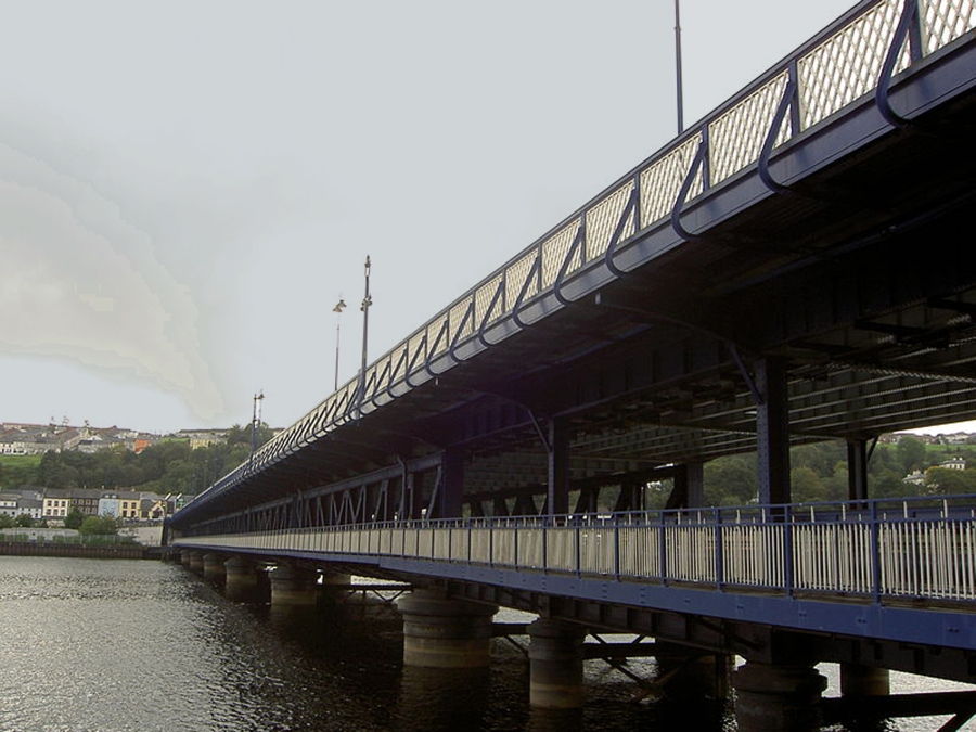
Derry is the second largest city in Northern Ireland. St. Columba founded a monastery on the east bank of the River Foyle in the sixth century, and for almost five hundred years Derry was primarily a monastic settlement. The secular city that followed eventually became an English garrison and was destroyed in 1608 by Irish rebels. Then in 1613, James I of England came up with a plan to subordinate Ulster by settling it with Protestants. Settlers from London and Scotland (The Irish Society) were granted a Royal Charter to build the city of Londonderry on the west bank of the River Foyle, opposite the ruins of Derry. The modern city covers both banks. While Londonderry is still the official name, most Irish call it Derry. As we neared the River Foyle, we passed the Derry Workhouse (1840). (A workhouse was a public institution in which the destitute of a community received board and lodging in return for work, usually under very strict and arduous conditions.) Surprisingly, it remained a workhouse until 1948. It's now a museum. We crossed to the west bank of the River Foyle on the double-deck Craigavon Bridge (railroad on lower level). In the roundabout at the end of the bridge was the "Hands across the Divide" peace monument (1992), built to commemorate the reconciliation between the Protestant and Catholic residents of the city. We could also see the very modern Peace Bridge (2011), a pedestrian bridge, just up the river.
The weather had improved, but there still was occasional light rain. Our first stop was at the Tower Hotel where we had tea and scones (11:40-12:15). I went out ahead of our group and had time to walk down the block to the Diamond and take a few pictures before the others came out.
Then we began our group walk around the old city on the walls. The circumference of the walls is a mile, but we only walked about half way around. As we walked, our guide gave us the history of "The Troubles" between the Catholic and Protestant residents of Derry. Although there had long been enmity between the two sides, the Troubles began in Derry with the Battle of the Bogside in 1969. (Bogside is the working class Catholic neighborhood just outside the old city walls.) Derry was also the site of "Bloody Sunday" (1972) in which 26 unarmed protesters and bystanders were shot by British soldiers (14 died).
Despite the Good Friday Agreement (1998) and
subsequent efforts at reconciliation, the brick walls
built to separate Protestant and Catholic areas in Derry
still stand. Our guide said that there just wasn't
money available to tear them down, but he also said most
residents are
more comfortable with the walls standing. Looking down
from the city wall, we could see several political
murals and signs in Bogside. One can only hope that they
remain more as tourist attractions than as omens of more
troubles.
By now the showers had stopped and the sun was in and out as we walked the walls (counterclockwise). Looking to the north, there was a great view of Bogside and, to the left, the rest of the city on the west bank. St. Eugene's Catholic Cathedral (1873) stood out. There were canon of different types (including ship cannon) scattered along the wall.
Just below the first (NW) corner of the wall stood
St. Columba's Church Long Tower (1788), a venerable
Catholic Church. It is said to have an exceptionally
beautiful interior, but we didn't have an opportunity to
visit it. (This church is not to be confused with the
Church of Ireland's much larger St. Columba's Cathedral
inside the walls).
A short distance further along, we came to tiny St. Augustine's Church (1872), a real gem set in a beautiful garden on the wall. Then came something not so beautiful. As we walked over the top of Bishop's Gate, I looked down on the street below and saw the ugly fence that still separates the Protestant and Catholic neighborhoods of Derry. The tower along the fence is the last remaining part of an old jail (1791). Right across Bishop Street from the fence is Alexander House, a home for the elderly. I don't imagine that they enjoy the view.
Just a short distance further along the wall was St. Columba Cathedral (1633). The Irish Society began construction of this church soon after the city walls were built. It is said to be the first Protestant cathedral built in Europe. (Others were converted Catholic cathedrals.)
Our tour of the walls was now finished. A sloping
driveway took us down into a commercial area of the
city, and the pub where we were to have lunch was just
around the corner. We got there about 1:00. Again we had
a big meal. Then we had free time to look around and
shop. Since it was Sunday, though, almost all the shops
were closed. We managed to find just one open in the Craft
Village. We were back on the bus at 3:30 and on our way.
We took a faster route back and got back to the ship in just over an hour. The ship sailed just after 7:00 while we were at dinner. The seas were very rough during the night as we left the Irish Sea and sailed into the North Atlantic.
Copyright © 2000-2023 DarrellPeck.com All rights
reserved. | |||||||||||||||||||||||||||||


.JPG)


